Road reference system
The reference system will label each and every road in Norway with a road category, a road number and a metering system.
Road divided into strekning, delstrekning and meters
Each road within each road category has a unique number. The road is split into smaller parts, first into strekning (section), which again is subdivided into delstrekning (subsection). Along each delstrekning we count meters, starting at 0 at the beginning of the next delstrekning.
The life cycle of road is divided into phases, starting with the construction fase (A, for anlegg = construction), followed by operational road status (V, for existing veg = road).
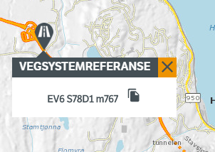
Together, this constitutes the complete road reference of the form Ev6 S78D1 m768 (Europaveg 6 Strekning (section) 78 delstrekning (subsection) 1 meter 768.
Complications at junctions and bifurcations
The above model with strekning and delstrekning is adequate for describing the main alignment of the road, but in complex junctions and bifurcations we need to add a bit more.
The idea is that any bifurcations from the main aligment is anchored at a point at the main alignment centerline, following the syntax of the previous section. We then add a new, separate labeling system and a separate metering system for the different parts of the bifurcations. In a motorway junction, the different ramps typically get a unique label and metering.
We have two classes of bifurcations:
- Those that are part of a junction
- kryss = junction
- kryssdel = part of junction
- everything else:
- sideanlegg side = displaced laterally, anlegg = construction
- sideanleggdel, del = part of
Example Sideanlegg
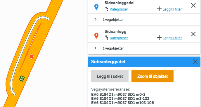
Here we show the anchor point (red) at the main center line Ev6 S184D1 m9087. The bifurcation has its own Sideanleggsdel number SD1, and metering system 0-106. Don’t be confused by the fact that the Sideanleggsdel is split into 3 segments (meter 0-3, 3-103 and 103-106).
Example motorway junction
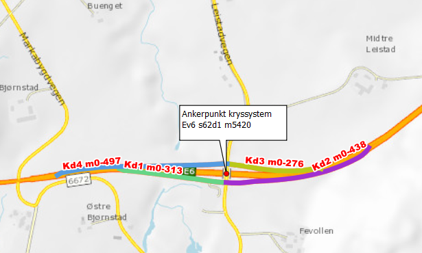
Here we show the numbering of 4 different ramps (kryssdel number Kd1-4) each with its own metering system. The anchor point (ankerpunkt) is shown in red.